
 |
Before there were good roads or railroads, the highways of commerce were rivers. There was no need for excavation, bridging or prep work. Build something that would float, put it in the water and away you
go – except, of course, where the river is shallow or has rapids, then a portage is required.
The location of what we know today as Murphy was influenced by the junction of the Valley and Hiwassee rivers, much like the reason they put fast-food restaurants and gas stations on the corners of intersections today. Add a river crossing on the Unicoi Turnpike beginning in 1819, and we have the Huntington community evolving into Murphy.
While railroads came and went, roads remained, steadily improved over the years and becoming the primary method of entry and egress.
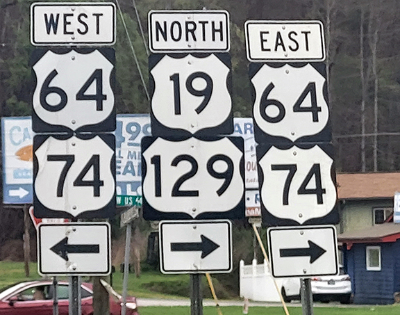
We drive them every day – to Asheville, Atlanta, Knoxville and Chattanooga, – usually without thinking of their numbers. When I grew up here, Ducktown to Murphy was U.S. 64. When I returned and heard that road referred to as U.S. 74 I didn’t know where it was. What I didn’t know then was U.S. 64 had always been U.S. 74, too.
The numbering system of U.S. highways began in 1926, with a general designation of north-south highways odd numbered, east-west highways even number. Numbering started with lowest numbers in the West, highest numbers in the East and lowest numbers in the North, highest numbers in the South.
Major north-south highways would end in “1.” Major east-west highways would end in “0.” A three-digit number would indicate a spur off a main route. Interstate highways would later follow the same system.
My unfamiliarity with U.S. 74 gnawed at me, but I did not know much about the other highways whose names I heard and roads I’ve traveled all my life. Here is the story of some of those.
U.S. 19 runs from the Georgia line at Bellview for 145 miles across western North Carolina into Yancey County, north of Asheville. At the Tennessee line, the highway splits and becomes U.S. 19 East and U.S. 19 West. It is the highway we take in Bryson City that runs through Cherokee and Maggie Valley. A few miles above the Georgia line, U.S. 19 runs concurrently with U.S. 64/U.S. 74 into Murphy.
U.S. 64 runs east and west for 2,326 miles, from southwest of the Four Corners in Arizona to Nags Head on the North Carolina coast. In Tennessee, the highway runs from Memphis through Chattanooga, Ocoee and into Cherokee County.
The state encompassing phrase, “From Murphy to Manteo,” is totally traveled on U.S. 64. The highway veers off U.S. 64/US 74 in Murphy and U.S. 64 goes through Hayesville and Franklin.
U.S. 74 begins at the juncture of Interstate 24 and Interstate 75 in Chattanooga and travels east and west to Wrightsville Beach.
The best way to describe the signage for U.S. 74 is poor. While it runs concurrently with I-75 to Cleveland, Tenn., the turn to take U.S. 74 reads only “U.S. 64 Bypass.” It runs concurrently with U.S. 64 until the split of the two highways east of the Hoover bridge in Murphy.
U.S. 129 runs for 582 miles, beginning in Chiefland, Fla., and running through Athens, Ga., and on through Blairsville and Murphy. From Murphy, the route is concurrent with U.S. 64/U.S. 74 until Topton, where the road turns left into Robbinsville and through Deals Gap at the state line, where U.S. 129 becomes the Tail of the Dragon, 11 miles of 318 curves loved by bikers and generally cursed by natives required to travel it to Knoxville. U.S. 129 ends at I-40.
In Brantley Gilberts’ million-selling country song “Bottoms Up” the highway is mentioned in the lines, “I see you and me riding like Bonnie and Clyde, Going 95, burning down 129.” Gilbert was raised in Jefferson, Ga., which U.S. 129 runs through.
State highways tend to be shorter that U.S. highways. N.C. 60 connects U.S. 64/U.S. 74 to the Georgia line at Culberson, where it becomes Spur 60, running from the Georgia line for 7.5 miles into Mineral Bluff. It is known in
Georgia as the Murphy Highway. (Blairsville residents also refer to U.S. 129 from Blairsville to Murphy as Murphy Highway. too).
N.C. 294 is a two-lane mountain road that never leaves the Nantahala National Forest, running from the Tennessee line to U.S. 64/U.S. 74. This road takes travelers past Hiwassee Dam School and Fields of the Wood. The 13.3-mile road was established in 1931. At the Tennessee line, the name of the highway becomes Tennessee 123 into Ducktown.
N.C. 141 is an 8.7-mile stretch of highway connecting Peachtree and Marble. It was established in 1954, and serves as a fast route from those in that part of the county to the hospital in Peachtree.
County roads spin off from one of the main routes already named. In the days of my youth, Route 4 sufficed, but with the coming of countywide EMS service with every road being named increases the speed and accuracy of response time. Route 4 of my youth is now known as Hiwassee Dam Access Road.
Our roads here are only a small part of the 157,724 miles of U.S. highways. And while designated U.S. highways, upkeep and maintenance of these roads falls to the state and the county through which they are routed. Your tax dollars at work.
Bruce Voyles’ local history column runs every other week in the Cherokee Scout. Email him at RoadsLessTraveled@cherokeescout.com.