
 |
Our Appalachian Mountains are no strangers to forest fires, as evidenced by the 2016 Gatlinburg, Tenn., fires and the ring of forest fires that surrounded us that year, requiring firefighters from across America to help fight our numerous fires.
Nineteenth-century forest fires were not fought. They generally burned themselves out with no efforts to extinguish them until 1905 with the forming of the U.S. Forest Service under the Department of Agriculture. Their mandated job is to manage America’s forests as a natural resource, managed for many purposes: timber, recreation, grazing, wildlife, fish and more.
The National Park Service, on the other hand, is vested in preservation, barely altering the existing state.
Preserving the value of the resources, i.e. preventing them from burning up in wildfires, falls on the U.S. Forest Service. It is a big job. The Forest Service today oversees 193 million acres and 155 national forests.
Only five years into their existence, the Forest Service faced a legendary fire known as the “Big Blowup,” a fire in Montana, Idaho and Washington with hurricane- force winds.
That fire burned more than 3 millions acres and killed 86 in 1910. Most of the dead were firefighters, including a crew of 26.
A 3 million-acre fire is 4,700 square miles. The estimated cost of the fire was over $1 billion in lost timber. That much timber on a freight train would be 2,400 miles long.
In comparison, the 2016 Gatlinburg fires, described as the worst disaster to befall the state of Tennessee, consumed 10,000 acres and killed 14.
Something had to be done to stop wildfires. In 1908, the goal was announced that all wildfires should be extinguished by 10 a.m. the following morning.
The Forest Service was given a budget increase and told to battle every wildfire. As a part of this fire districts were implemented.
Another important part of improving firefighting came from William Bushnell Osborne Jr., a Forest Service employee at Mount Hood. He invented a 14-inch circular map showing a 360 degree view of the surrounding mountains with a fire lookout in the center. The Osborne Fire Finder was called an alidale.
In the first month of testing the alidale, 131 fires were located. When a fire was located, the degree direction was noted as a line of sight, and compared with a degree direction from a second fire tower, the intersecting lines would pinpoint the fire’s location.
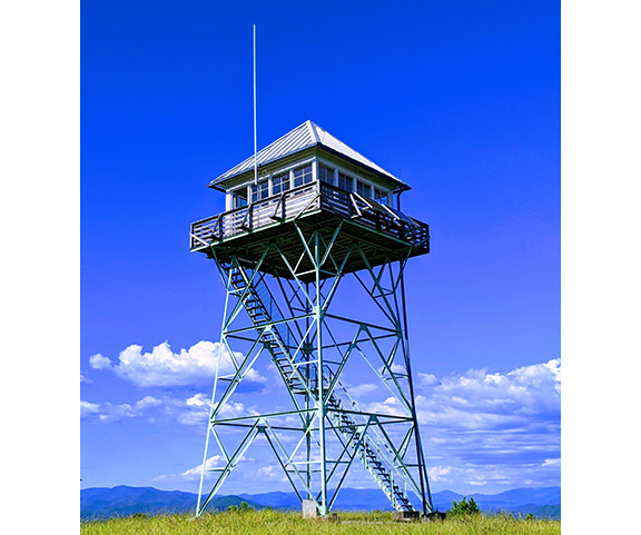
Thus, the necessity for a fire tower was born to house the alidale and the lookout manning it.
Some fire towers were rock buildings on a mountain top, while most were erected on metal frames purchased from windmill manufacturers. Heights varied by the needs of the location.
On remote mountaintops, phone lines were not always an option – and some early fire towers communicated by heliographs and carrier pigeons.
In 1924, improvements in the alidale increased the size to 24 inches. Lupold and Volpe (better known today as a manufacturer of binoculars and rifle scopes, but a leading maker of surveyor equipment at the time) was contracted to improve the optics of the alidale.
Eventually, there would be 8,000 fire towers operating, with 611 of those constructed by the Civilian Conservation Corps during the Great Depression. During World War II, some of those towers were also utilized as lookouts for approaching enemy airplanes.
Today, 2,000 fire towers survive, some available in Western states for overnight tourist rentals.
Many of the towers near us have been removed, but a single important tower remains in Cherokee County on Panther Top, accessible by an access road off N.C. 294. It was a common destination for a Sunday afternoon picnic, and for your author one memorable Boy Scout hike in the snow to the tower and back from N.C. 294, a heavy undertaking for a plodding troop of 12-year-olds.
Locals often refer to the fire tower location by its more familiar moniker, “Painter Top.”
The Panther Top tower was erected in 1940, manufactured by Marshall-McClintock and is 2,293 feet above sea level. The small enclosure on the top of the tower, called the view shed, is 14-by-14 feet with a catwalk, and still houses an alidale. The tower is 30 feet tall.
In the 1970s, technology improved with aerial surveillance and satellite imagining reducing the need for manned fire towers, but the Panther Top tower is maintained in working condition and still put into use by the Forest Service during high risk fire conditions.
When the blizzard of 1993 destroyed the existing phone lines to the tower, it was decided to not rebuild the costly phone line. Adding to the problem with the tower’s isolated location, vandals started damaging the tower. The Forest Service closed the tower to visitors and a locked gate was erected to restrict public access.
The road to the tower is usually closed to vehicles but open and popular with hikers who walk the two miles or so beyond the gate. A couple of weekends a year during fall color season the road is opened to vehicles to allow non-hikers to enjoy the magnificent view – and to step back into history.
In 1997, Panther Top Tower was named to the National Historic Lookout Register, and a brass plaque was installed at the site naming many of the men who had manned the tower over the years: Glen Beaver, Tyrone Burnette, Chester Greene, L.C. Loudermilk, Lee McClelland, Jess Rich, Ralph Rogers, Steve Rowland, Harvey Stiles, Jack Thompson and Grady Waldroup.
The tower was open to the public this year Oct. 25-26, and Nov. 2-3, from 10 a.m. to 4 p.m.
To visit the tower other days of the year requires an easy hike, but one worth the wide view.
Bruce Voyles’ local history column runs every other week in the Cherokee Scout. Email him at RoadsLessTraveled@cherokeescout.com.