
 |
Shortly after I became a published author, the Murphy Public Library hosted an “author’s day,” and I was invited to read excerpts, along with John Parris and Bob Terrell, then editor of the Asheville Citizen.
In Terrell’s address to the schoolchildren, he said he had read every Louis L’Amour book. It seemed worthwhile. I would read all his books, too, reveling in the tales of the Sacketts, Kilrone and Chantry.
And I found my favorite, To the Far Blue Mountains, in which a Sackett leaves his familial home on Shooting Creek in western North Carolina via canoe, and journeys down the Hiwassee to the Little Tennessee. Then down the Tennessee to the Ohio, the Ohio to the Mississippi, and then up the Arkansas River – to Colorado.
Sackett’s fictional journey illustrates the importance of rivers in early America. There were a few ages old footpaths, fewer roads, most roads in name only, nearly impassible in bad weather.
Larger population areas were the first to construct decent roads, some gravel, some of boards and poles called a corduroy road, a McAdam road, starting with coarse gravel and layered with steps of finer gravel and sand (or tar today). The land was usually flat, built without the advanced engineering required for mountain road building.
With footpaths and rivers the only access, our part of the world was isolated. Since the Cherokee held the land, it seemed to work out fine.
King George III decreed the western border of the colonies to be the crest of the Blue Ridge, which was a green light for French traders moving out from the Mississippi river to paddle up the rivers to such places as western North Carolina, without the required trading license from the British authorities in Charleston.
After their defeat in the French & Indian War in 1760, French traders retreated, leaving little trace of their being here save for a river called the French Broad.
The narrow trail that came through Cherokee County from the Charleston settlements to the heart of Cherokee territory was named the Indian Path. It was so narrow that a small cannon could not be tied sideways on the trail horses. Buckskins for trade were carried on the backs of men. Trader’s goods entered the same way.
While American communities along rivers and good roads prospered it was not the case here.
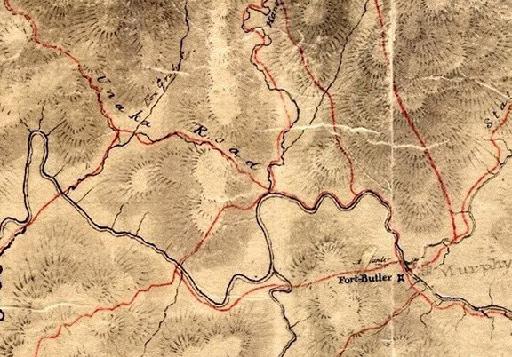
Change came with the opening of the Unicoi Turnpike, a bona-fide road for wagon traffic and routed to run along the more level ground beside rivers. The Cherokee allowed the road via treaty in 1819.
A stand was built every 10 miles, with lodging and corrals to herd the livestock (usually pigs). White men ran the stands, and built cabins and gardens.
In the 1820s, a Scottish trader chose a spot on the Unicoi Turnpike near the merging of the Hiwassee and Valley rivers as the perfect spot for his trading post and ferry.
A.R.S. Hunter chose the west bank of the Hiwassee. The post office was authorized under “Huntington.”
The spot was not hewn from remote wilderness. It was more akin to opening a gas station on the interstate. If one entered this area, it would be via the Unicoi Turnpike. The road was not free. A toll keeper was stationed in the Unicoi Gap at the state line with Tennessee.
A primary Cherokee Removal fort, Fort Butler, was built alongside Hunter’s trading post. One visiting general was impressed being served French wine imported by Hunter via the Turnpike.
Army roads soon connected Fort Butler to outlying Forts Hembree, Delaney and Montgomery (Hayesville, Andrews and Robbinsville today). Once assembled at Fort Butler, the Cherokee were marched to Fort Cass via the Unicoi Turnpike, with the intention of transporting the Cherokee by water to Oklahoma – before abandoning the plan and moving overland.
America’s larger river towns were soon connected with decent roads and railroads in a network as early as the 1850s. Railroads did not find their way to our area until around 1888 and lured by the prospect of hauling copper and ore from the Ducktown mines.
Railroads enabled easier importation of goods and expanded the economic base of the county. Via the railroad, my great-grandfather received delivery of a disassembled house from Sears-Roebuck. It still stands near Hiwassee Dam.
Good roads would come much later. U.S. 64 was not created until 1926, U.S. 74 in 1927. Many of those roads, including U.S. 64/74 through the Ocoee Gorge, was gravel into the 1940s.
Each method of transportation came with technologies and improvements that in turn altered life here. Our remote mountainous terrain and lower population often left us behind emerging technologies and transportation improvements. It is much that way today.
I have a daughter and grandchildren in Houston. The only two lane roads I travel for that 15-hour trip are within 30 minutes of Murphy.
The history of our county is intertwined with how people got here, whether by trail, river, railroad or highway. Improved roads did not always follow the older trails. Even the original Unicoi Turnpike route is different from the current dirt road connecting Coker Creek to Unaka. (A section of that original road is still preserved as a historical site nearby.) Persimmon Creek and Grape Creek were close communities connected by a small bridge over the Hiwassee – until the building of Hiwassee Dam created a new lake between those two communities.
Transportation improvements have always brought change. Soon there will be a four lane connecting Hiawassee, Ga., and Highway 515 to Hayesville, and coming improvements on U.S. 129 from Blairsville, possibly turning the Murphy area into a bedroom community to Atlanta and adding easier access to transplants whose presence and different
traditions are also visibly impacting this place we call home.
Whether that is good or bad remains to be seen.
Bruce Voyles’ local history column runs every other week in the Cherokee Scout. Email him at RoadsLessTraveled@cherokeescout.com.