
 |
No one has ever summed up the lure of the mountains as succinctly as John Muir in a letter to his sister. “The mountains are calling and I must go.”
For those of us referred to as “natives,” that call was felt by our ancestors who first came here and was passed down through the blood – validated by the numbers of us returning home in our later years. From the number of out-of-state tags, others are yielding to that call. It is nothing new.
Our mountains have been roamed by native Americans, adventurers and traders but also by scientists and botanists. William Bartram’s book describing his journeys near here is still in print, but he was not the only one.
French scientist Andre Michaux, explored into
the Black Mountains and further east in 1789. John Fraser would follow. The man for whom the Fraser Firs are named walked our woods.
In the 1830s, a professor from the University of North Carolina ventured into the mountains to measure them. In those days, Mount Washington in the White Mountains of New Hampshire was considered the tallest mountain east of the Mississippi. Within North Carolina it was assumed that Grandfather Mountain was the loftiest clime in the state.
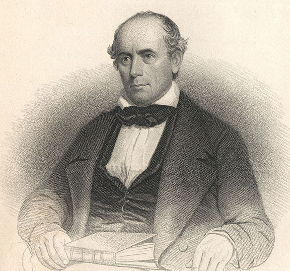
Professor Elisha Mitchell was a Yale graduate and began teaching math and natural philosophy at UNC in 1818, and sometimes serving as acting president of UNC. He was ordained a minister in 1821.
Mitchell measured 17 peaks in western North Carolina, climbing Grandfather Mountain for measurement in 1828. In the Black Mountains, he saw a mountain known as Black Dome that he measured in 1835, and again in 1838 and 1844. He released his findings that Black Dome was the highest mountain in North Carolina – and also the highest mountain east of the Mississippi. After five trips to Black Dome he refined his measurements, eventually declaring the mountain to be 6,672 feet in elevation. Mount Washington in New Hampshire was measured at 6,288.
One man disagreed with Mitchell, Thomas Lanier Clingman of Asheville, a former student of Mitchell’s. He was a U.S. Congressman, later to be a U.S. Senator and Confederate General, with a reputation of self-confidence to the point of arrogance and unrelenting in a quarrel.
Clingman’s belief was the tallest mountain was Smoky Dome, and disputed Mitchell’s claim publicly, declaring Mitchell has not measured Black Dome at all but had measured the wrong peak. Clingman published his claims in 1855, Mitchell immediately responded back with a newspaper article and their disagreement blossomed.
Rather than argue with Clingman, Mitchell returned to Black Dome in June of 1858 to confirm his measurements, leaving a daughter and servant at the foot of the mountain and working with his son while staying at Halfway House, a summer home built by William Patton of Charleston on a ledge of the mountain.
Mitchell’s guide during his earlier 1844 exploration had been Big Tom Wilson, a legendary guide and bear hunter who lived near there, and Mitchell left Halfway House alone with the announced intention of visiting Wilson, some distance away, saying he would be back Monday. It was the last time he was seen alive.
Mitchell did not return Monday, Tuesday or Wednesday, and hundreds began a search. Apparently, Mitchell had become lost and attempted to follow a small stream he knew ran through the Wilson farm, but along the way slipped off a cliff, landing in the water below where he drowned. He was found by Big Tom Wilson. The watch he was carrying stopped at 10 minutes past 8 p.m.
Mitchell was buried in Asheville, but the next year his body reinterred on Black Dome, where his remains rest, on the mountain that today bears his name, Mount Mitchell.
From 1856-60, the U.S. Geological Survey began naming the East Tennessee and Western North Carolina mountains and utilizing newer methods of measurement. Their conclusions were Mount Mitchell (formerly Black Dome) was 6,684 feet above sea level.
Smoky Dome was renamed for Clingman, known today as Clingman’s Dome, the highest point in the Great Smokies, and the tallest mountain in Tennessee at 6,642 feet.
A scientist from Princeton confirmed many of those measurements, exploring
and measuring mountains from Maine to South Carolina beginning in 1854. His name was Arnold Henry Guyot, and he would lend his name to the fourth
highest peak, Mount
Guyot, at 6,621 elevation. It was his choice to rename Smoky Dome as Clingman’s Dome.
But that is not the end of the story. Utilizing satellite imagining the peaks were remeasured in 1993, and while Mount Mitchell remains the highest east of the Mississippi, the second highest goes to Mount Crain in the Black Mountains at 6,647 feet. Clingman’s Dome comes in at third.
And with the political correctness wiping the names away of anything to do with the rebellious Confederates of the Civil War, Clingman’s Dome is now under fire.
In 2022, the Eastern Band of Cherokee Indians Tribal Council passed a resolution to change the name of Clingman’s Dome to Kuwohi, translated to mean “mulberry place.” The tribe petitioned the U.S. Board on Geographic Names in January of this year for the name change, inspired by Yellowstone National Park renaming Mount Doane “First Peoples Mountain.”
The resolutions reads: “The name Clingman is not derogatory in and of itself, but the history shows the
act of changing the name of Kuwahi to ‘Clingman’s Dome’ was racist and that the racist action should be acknowledged and corrected.”
Resolutions supporting the change have been passed by Buncombe, Haywood, Jackson, Macon, Swain, Graham, Clay and Cherokee counties, as well as the towns of Asheville, Andrews, Murphy, Hayesville, Fontana Dam, Lake Santeetlah, Robbinsville, Canton, Clyde, Maggie Valley, Waynesville, Dillsboro, Sylva, Webster, Franklin, Highlands and Bryson City.
Bruce Voyles’ local history column runs every other week in the Cherokee Scout. Email him at RoadsLessTraveled@cherokeescout.com.