


Weather service releases full report
The National Weather Service has released its report about Hurricane Helene, which ravaged the Southeast in September 2024 – six months ago – and left western North Carolina dealing with death and destruction from which it is still recovering.
Helene passed through three states before reaching North Carolina before sunrise Sept. 27, but it suffered the worst destruction, most deaths, highest rainfall, fiercest wind gusts and record flooding from the storm, according to the report.
Helene tore through the Southeast headed straight for Cherokee County, according to forecasts at the time. However, it shifted slightly to the east during the night, and although the remnant’s eye passed just west of Andrews through Hanging Dog before entering Graham County, the most intense parts of the storm crossed over Buncombe and surrounding counties.
Impacts in Cherokee County were light; even power outages were uncommon, although cell phone service was knocked out for several days. For those with internet service, they sawreports of devastation from their neighbors to the east. Local residents mounted relief efforts knowing that they dodged a bullet.
What follows are transcripts from the National Weather Service’s report about Helene’s impacts, with the Cherokee Scout emphasizing the overall effects in western North Carolina.
Summary
Helene originated from a Central American Gyre that developed on Sept. 20, 2024.
Helene made landfall in the Florida Big Bend region as a category 4 hurricane (on the Saffir-Simpson Hurricane Wind Scale) on Sept. 26. The storm brought catastrophic inland flooding, extreme winds, deadly storm surge, and numerous tornadoes that devastated portions of the Southeastern United States and Southern Appalachians.
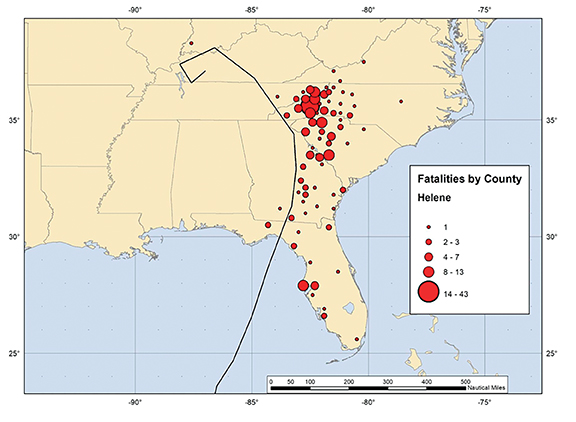
Helene is responsible for at least 249 fatalities in the United States (including at least 175 direct deaths), making it the deadliest hurricane in the contiguous United States since Katrina in 2005. Helene also produced tropical storm conditions and minor damage across portions of Mexico and Cuba.
Deaths
- Florida 18, including 14 from storm surge and 4 from wind. Also, 16 indirect deaths.
- Georgia 28, including 26 from wind and 2 from tornado. Also, 9 indirect deaths.
- South Carolina 26, including 24 from wind and 2 from flooding. Also, 23 indirect deaths.
- North Carolina 85, including 77 from flooding and 8 from wind. Also, 21 indirect deaths.
- Tennessee 15, all flooding. Also, 1 indirect death.
- Virginia 2, from wind. Also, 1 indirect death.
- Indiana 1, from wind.
Total direct deaths: 175.
Total deaths: 249.
Western North Carolina
Helene is the most devastating natural disaster in western North Carolina history. In addition to the 85 direct and 20 indirect fatalities in North Carolina, at least 21 injuries were reported in the state, and the Coast Guard rescued at least 865 people, mostly from flood waters.
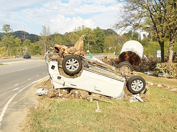
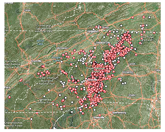
Rainfall associated with Helene and rains that preceded it days before resulted in catastrophic flooding impacts across western North Carolina and eastern Tennessee, particularly in mountainous regions, where landslides and debris flows destroyed numerous homes, roads, bridges, electrical infrastructure and water treatment plants.
Media reports indicate that the storm damaged or destroyed more than 125,000 housing units across western North Carolina. The N.C. Forest Service estimated 822,000 acres of damaged timberland, which resulted in $214 million in damages to state forests.
In extreme examples, trees on entire mountainsides were blown down in the higher elevations of North Carolina. Many people in remote areas were cut off due to landslides, fallen trees and debris flows, which destroyed numerous roads and bridges in many smaller mountain communities.
Many residents did not have access to clean water or electricity for a long time after Helene’s passage.
In Buncombe County, flash flooding, river flooding and landslides were directly responsible for at least 37 deaths. Landslides killed 16 people in the Fairview area.
In the towns of Swannanoa and Black Mountain, at least nine people drowned in the Swannanoa River’s floodwaters, where multiple homes, businesses and roads were destroyed. At least six of the deaths occurred in Asheville, while the exact locations of the other six deaths are unknown.
More than 490 water rescues were performed across the county. Historic river flooding was particularly damaging to the lower-lying areas of Asheville along the French Broad and Swannanoa Rivers.
In the historic Biltmore Village, located on the south bank of the intersection of where the Swannanoa River flows into the French Broad River, lower-lying buildings were severely inundated with deep water or swept away. Asheville’s historic River Arts district, located 1 mile north of the Biltmore Estate along the French Broad River, was largely destroyed.
In addition, significant flooding was reported along the Ivy River in Barnardsville, where multiple structures were inundated. In the southeast part of the county, flooding from the Broad River impacted several structures and multiple roads.
At least 300 landslides occurred in the county. Helene caused extensive damage to Asheville’s water treatment infrastructure, and clean water was not restored to the city until Nov. 18 – 53 days after Helene passed through.
Power was restored to more than half of Asheville’s customers within a week, although media reports indicate that 25,000 people were still without power two weeks after Helene.
Tens of thousands of trees were knocked down across the county, with hundreds down on homes due to a combination of strong wind gusts and debris flows. Media reports indicate that more than 560 structures were destroyed and at least 901 structures sustained major damage in the county, with an additional 8,920 homes/buildings incurring minor or moderate damage.
Another area that was devastated was the Chimney Rock and Lake Lure area of Rutherford County, where numerous landslides and debris flows destroyed the majority of buildings, homes and businesses.
In addition to the landslides, catastrophic flash flooding along the Broad River was responsible for portions of the damage that occurred in these communities. This was the highest crest of the Broad River in this area by several feet and the most severe flooding in recorded history for the area.
Bridges were wiped out and roads were completely washed away, essentially cutting off communities. Much of the debris from these communities piled into the waters of Lake Lure. Tens of thousands of trees are estimated by county emergency managers and the National Weather Service to have fallen due to a combination of strong wind gusts and debris flows.
Three direct deaths occurred – two from falling trees due to wind and one from freshwater flooding. Numerous water rescues were reported, with hundreds of homes and buildings destroyed.
More than 20 inches of rain was reported in portions of Henderson County. Catastrophic flash flooding occurred along the Rocky Broad River and its tributary Reedy Patch Creek, and numerous homes were swept away along both streams. Major flooding also occurred along Mud Creek and Bat Fork, with numerous businesses and other structures inundated in the Hendersonville area.
Eight direct deaths occurred in Henderson County – five in Hendersonville from freshwater flooding, three from landslides in the Bat Cave area – along with numerous water rescues. According to media reports and county officials, roughly 300 homes/buildings in the county were destroyed, with about 1,400 others incurring major damage.
At least 86 landslides were documented in the county, and numerous roads were damaged or washed out. Hundreds of trees were down on homes due to strong wind gusts.
Impacts in Transylvania County were also significant. Dozens of homes were damaged in Rosman with some structures destroyed after being inundated with several feet of water from the French Broad River.
Flooding also occurred along the Davidson River area of Pisgah National Forest, where several water rescues took place. Madison and Yancey counties, located along the Tennessee border, experienced devastating damage from Helene.
In Madison County, aerial drone footage shows floodwaters from the French Broad River inundating the majority of buildings in downtown Marshall.
Farther downstream, the Town of Hot Springs was also devastated, where floodwaters from the river destroyed numerous businesses and critical infrastructure. Water, sewer, electricity and communication systems were heavily impacted.
The French Broad River at Hot Springs set a record crest, surpassing the level from the Great Flood of 1916 by 0.3 ft. Four people died in Madison County, along with numerous water rescues reported. Hundreds of homes and buildings were either destroyed or sustained major damage.
In Yancey County, which includes Busick where the largest storm-total rainfall occurred, rivers and their tributaries inundated hundreds of homes, with some structures completely destroyed. More than 200 landslides occurred, damaging or destroying numerous roads.
Media sources indicate about 1,400 homes/buildings were destroyed in the county, while 2,300 others were severely damaged, with an additional 2,000 structures incurring minor to moderate damage. The Coast Guard performed numerous water rescues. There were ten direct fatalities in Yancey County – eight from flooding, one in a landslide and one in a vehicle.
Farther north along the Tennessee border, Mitchell, Avery and Watauga counties are home to the cities of Spruce Pine, Bakersville, Banner Elk, Newland and Boone. Some rivers, creeks and streams in Mitchell County rose to their highest levels in recorded history, and numerous water rescues took place. The highest reported rainfall in the county was 23.31 inches.
More than 200 landslides were documented in the southern part of Mitchell County, near the McDowell County line. Very strong wind gusts knocked down an estimated 100,000 trees in Mitchell County.
Several bridges and roads were wiped out and washed away, cutting off several small communities from the outside world. One direct death in Mitchell County was due to drowning from the floodwaters of the North Toe River.
In Avery County, where up to 22.85 inches of rain was recorded, numerous homes and businesses in Downtown Newland were inundated and damaged by floodwaters from the North Toe River, with several structures swept away. Dozens of landslides occurred in this area, damaging or destroying multiple structures and killing three people.
Two additional fatalities in Avery County are attributed to flooding.
In Watauga County, flash flooding occurred in downtown Boone, where water was deep enough to enter homes and businesses. Several streets in Beech Mountain were washed out and destroyed by floodwaters.
Multiple vehicles became stranded on the flooded roads. There were at least 220 rescues in Watauga County (mostly in vehicles). A total of 118 buildings were destroyed, 479 with major damage and 538 with minor or moderate damage. Among the damaged buildings include several at Appalachian State University due to flooding from Boone Creek, which inundated some of the classroom buildings.
In McDowell, Burke, Caldwell and Cleveland counties, major flooding impacts occurred and damaging wind gusts knocked down many trees. In the western half of McDowell County, rainfall amounts of 15–22 inches fell, and hundreds of landslides were documented.
The Catawba River near Pleasant Gardens surpassed its all-time record river level by more than 4 feet. Dozens of structures were damaged or destroyed in the Old Fort area along with some being swept away, and there was one reported fatality.
Tens of thousands of trees are estimated to have fallen in McDowell County, with hundreds down on homes, vehicles and power lines.
In Burke County, major flooding occurred along the Catawba River and its numerous tributaries (with some of the gauge sites recording record flooding), inundating numerous homes (with some swept away) and prompting swift water rescues. Landslides washed out many roads, and nearly the entire county was left without power or water after the storm. In Caldwell County, hundreds of structures and roads were inundated and damaged or destroyed, several landslides occurred, major flash flooding and river flooding occurred, and several homes had roof damage due to strong wind gusts.
In Cleveland County, numerous homes were inundated and damaged near Abes Mountain Road. Widespread trees and power lines were down across the county, including several on houses and vehicles in the Shelby area, and two people were killed by falling trees during the storm while they were outside.
To the west of Asheville, significant damage occurred in Haywood County. Floodwaters from the East Fork of the Pigeon River swept through the Cruso community, causing significant damage to structures, vehicles and road infrastructure.
Record catastrophic flooding occurred on the Pigeon River from Canton and Clyde downstream to the Tennessee border. Numerous buildings in Canton were inundated.
Around 600 homes were impacted by flooding in the county, with a couple of hundred of those destroyed. Numerous vehicles were swept away or damaged, and hundreds of people were rescued. Many roads and bridges were damaged or destroyed.
This includes part of Interstate 40 along the North Carolina/Tennessee border, which was washed out and destroyed by overflowing waters from the Pigeon River, which parallels the interstate for several miles from Haywood County, North Carolina into Cocke County, Tenn.
Coming next week: Winds, tornadoes and rainfall.