
 |
Growing up here, the main highway into town was always “64.” Sometime in the 35 years I spent away the “74” designation began to take precedence.
Actually, the four-lane highway from Cleveland, Tenn., to Murphy is U.S. 64/74, with U.S. 64 splitting off just over the Hoover Bridge and continuing to Hayesville.
It is a major east-west highway, and from Chattanooga, Tenn., to Asheville the road is one of the most direct routes. It is a highway of history as well as a highway of utility.
With Hurricane Helene demolishing part of Interstate 40, what was once a secondary route through Cherokee County has again become a primary highway for trucking goods east and west. This direct route is four lanes most of the way except for two gorges, the Ocoee and Nantahala.
In a nine-mile stretch of the Ocoee Gorge recently, I met 31 18-wheelers. The Ocoee Gorge section of highway between Cleveland and Murphy bears five names: U.S. 64, U.S. 74, the Ocoee Scenic Byway, the River Road and, as it has been since the 1850s, Old Copper Road. The Ocoee Scenic Byway courses 26 miles, much of it through the Cherokee National Forest.
The road between Ducktown, Tenn., and Cleveland was conceived by local businessman John Caldwell, who began construction of the toll road beginning in 1851 for the purpose of hauling copper ore in wagons to the railroad in Cleveland, thus the name of Old Copper Road. The construction cost was $22,000. (more than $900,000 in today’s money).
Much of the labor was provided by Cherokee who escaped the removal, working for cheap wages in exchange for discretion – as there was still concern that they, too, might be removed if discovered. The removal had only been 12 years earlier. They didn’t quite understand the removal was primarily a land grab.
Once completed in 1853, the trip hauling copper took two days down. The return trip was more uphill and took a half day longer. Haulers would stop overnight, usually at lodging known as the Halfway House, purchased by Capt. Julius Raht in 1866. Raht commanded most of the copper mines at Ducktown.
One of the better known wagon haulers was Fiddling George Barnes, noted for playing the fiddle, a gift from Raht, as entertainment for the overnighters.
Barnes was one of the few survivors of the John P. Gatewood raid through Bradley and Polk counties during the Civil War. Twenty-one victims did not survive that bloody raid, but Barnes survived a pistol round to his head, although his vision was permanently hampered by Gatewood’s shot. His fiddle is on display at the Burra Burra Mining Museum in Ducktown.
Copper loads were limited to 500 pounds per mule or oxen. An eight animal team meant a couple of tons loaded on a wagon traveling a rough rutted road. The wagons commonly bogged down and the animals whipped to pull the wagon free. Barnes had a different approach, choosing to fiddle to his animals as the incentive to work harder pulling the wagon.
Barnes was honored with taking the last wagon load of copper down Old Copper Road before the railroad came to Ducktown providing a more efficient way to move the copper. Much of Old Copper Road runs along the Ocoee River. A 5-mile section of the original roadbed is preserved as a hiking trail near the Ocoee Whitewater Center.
This 93-mile long river begins in Union County, Ga., as the Toccoa River until it reaches the Tennessee line in Copperhill. The name changes at the bridge between McCaysville, Ga., and Copperhill, and there the river becomes the Ocoee.
The Ocoee takes its name from the Cherokee word for the purple passionflower, while Toccoa is from the Cherokee word meaning “Catawba place,” or simply “beautiful.”
But change was coming to the Ocoee. By the turn of the century, technology had turned to electric power and to fill that demand in 1910, the Eastern Tennessee Power Co. formed to dam the Ocoee River and provide electricity to Chattanooga, 30 miles away. The first dam was designated Ocoee Dam No.1.
The idea was nothing new. As early as 1810, Congress had considered damming the Ocoee between the Sugar and Bean mountains and setting up a series of locks and dams between the Ocoee and the nearby Conasauga River. The Ocoee’s watershed flows to the Mississippi while the Conasauga’s flows into the Chattahoochee. Plans were abandoned because at the time the government could not secure a lease from the Cherokee.
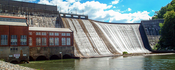
One hundred years later, J.G. White Construction Co. began work on Ocoee No. 1 in 1910. The small community there was named after the Parks family, Parksville.
More than 1,200 workers were employed with separate quarters for, as they specified, “Negros, Irishmen, Hungarians and Bulgarians” and another section for Italians. An average day resulted in 3,348,000 pounds of concrete being poured.
Electricity was being produced by February 1912.
In celebration of the dam, the top of the Hamilton Bank Building in Chattanooga illuminated a sign in 5-foot letters reading, “Plucky Electrical City.”
The lake created by the dam was named Parksville Lake. The lake has 109 miles of shoreline with a 9-foot fluctuation of lake levels annually. Like the Ocoee, the lake runs alongside U.S. 64/74, with the lake waters covering that end of Old Copper Road.
The dam initially boasted five units provided 18 megawatts of electricity. A steam plant was added adjacent to the dam and assisted in generating electricity from 1916-54.
Ocoee No. 1 is 135 feet high and 840 feet long, and today can generate 19,200 kilowatts after being upgraded between 1989-91. It is generating electricity today, 113 years later.
This was the first dam on the Ocoee, but not the last. Those other dams – and the coming of the Tennessee Valley Authority – is the subject of my next column.
Bruce Voyles’ local history column runs every other week in the Cherokee Scout. Email him at RoadsLessTraveled@cherokeescout.com.