
-
 11/9/23
 -
 11/8/23
 -
 10/27/23
Fire agencies added a third 20-person hand crew as the Collett Ridge Fire poses a threat to structures for the first time since it was ignited during a thunderstorm around Oct. 21-22.
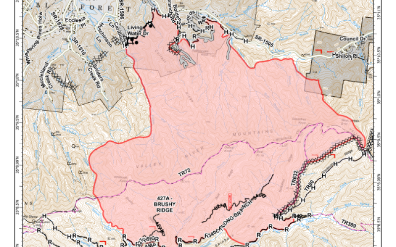
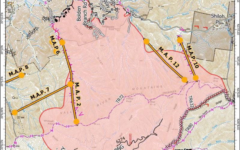
The fire area has grown by about 400 acres over the past 24 hours. The size was calculated at 4,372 acres. Containment is estimated at 5 percent.
It is the first time a containment figure has been reported and the first time structures have been reported threatened.
Here is the report:
Collett Ridge Fire Update: Nov. 9, 2023
- Size: 4,372 acres
- Containment: 5%
- Start Date: 10/23/2023
- Origin: Approximately 4 miles south of Andrews, NC
- Total Personnel: 156
- Resources: Three 20-person hand crews, 13 Engines, 1 water tender, 1 dozer, 2 helicopters, 1 air attack platform, and overhead personnel
- Structures Threatened: 16, located northeast of the fire, firefighters on scene providing structure protection
- Structures Lost: 0
- First Responder Injuries: 0
Current Situation: on Wednesday, firefighters established containment lines and began clearing leafy debris from around homes and buildings and cutting back any overhanging branches to prepare the structures to be more resilient if the fire comes close.
Currently there are 16 threatened structures to the north/northeast, firefighters are on scene providing structure protection as needed. Crews patrolled the burned area to the north of the fire near the communities of Lord’s Way/Bolden Branch, no hotspots were detected. Firefighters began scouting potential locations for containment lines to the west of the fire within the Snyders Creek and McClellan Creek areas. Southern portion of the fire was burning to the north of Tathum Cabin Branch and northwest of County Corners. Aircraft was used to slow the progression of the fire to the west using 33,000 gallons of water, which was drawn from Nantahala Lake.
On Thursday firefighters will continue strengthening handline to the northeast of the fire and providing structure protection as needed. Crews will begin constructing handline on the northwest side of the fire within the Snyder Creek and McClellan Creek areas to tie into a dozer line along the western side south to Big Stamp. On the southern side firefighters are working to keep the fire to the north of Fires Creek Road and may perform firing operations as conditions allow near Cold Springs Branch and Shinbone Ridge.
Weather and Fire Behavior: Increasing cloud coverage over the fire area with temperatures into the mid 70s, and increased humidity. West winds of 4-8 mph with gusts up to 15 mph. Despite the increased humidity today, dry conditions will persist due to the increased temperatures. Fire activity and growth are expected to continue. Light rain is forecasted beginning Friday.
Smoke and Air Quality: The inversion layer, which causes the smoke to settle into the valley, is expected to lift by mid-day, improving visibility and air quality in the river valley. Per the North Carolina Department of Environmental Quality Cherokee, Clay and Macon counties may experience Code Red air quality conditions, defined as air that is unhealthy for anyone to breathe. Residents should consider limiting prolonged or heavy exertion outdoors in these areas. Anyone sensitive to air pollution, including children, older adults and people with asthma, should avoid outdoor exertion. Air quality information available at airquality.climate.ncsu.edu/
Closures: For public and firefighter safety the following road and area closures are in effect due to increased fire activity and suppression operations in the area from Big Stamp east to Shinbone Ridge to Signal Bald and a road closure is in effect from the intersection of Little Fires Creek Road, 340B, and Fires Creek Road, 340. The Rim Trail is temporarily closed for approximately 7 miles from Big Stamp to Shinbone.
Burn Bans: Due to increased fire risk, the N.C. Forest Service has issued a ban on all open burning and has canceled all burning permits for Burke, Cherokee, Clay, Cleveland, Gaston, Graham, Henderson, Jackson, Macon, McDowell, Polk, Rutherford, Swain and Transylvania counties effective 5 p.m., Sunday, Nov. 5, until further notice.
The U.S. Forest Service has implemented fire restrictions across the Pisgah and Nantahala National Forests. To view the closure order visit www.fs.usda.gov/alerts/nfsnc/alerts-notices
Evacuations: No Evacuations at this time. Evacuations will be issued by the Cherokee County Emergency Management Office. To sign up for alerts visit www.nixle.com or text your zip code to “888777” to automatically sign up.
For updates about the Collett Ridge Fire, please follow the National Forests in North Carolina at U.S. Forest Service - National Forests in North Carolina for additional updates.