
-
 Map
Map
The Collett Ridge Fire was subdued by rainy weather, giving firefighters a chance t build up defenses before drier, warmer weather arrives Monday and Tuesday ahead of more predicted rain starting Wednesday.
On Friday, a State of Emergency was declared by Cherokee County Board of Commissioners Chairman Cal Stiles in which he asks county residents to pray.
Here is the full declaration, and beneath it, this morning’s official fire update:
DECLARATION OF A LOCAL STATE OF EMERGENCY
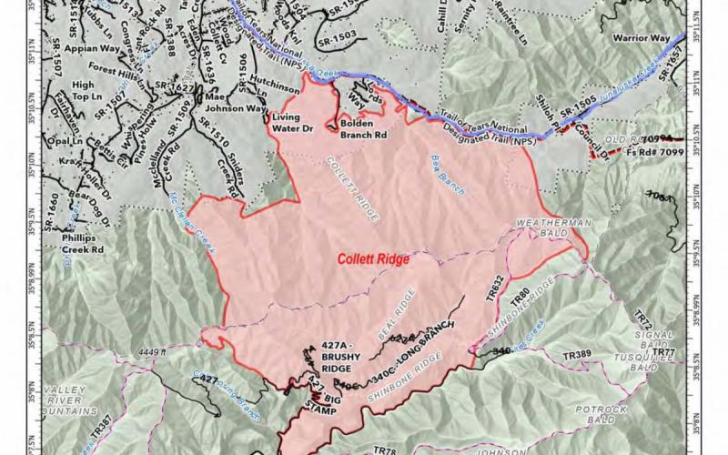
WHEREAS, the Collett Ridge wildfire has consumed, as of 9 November 2023, over 4000 acres of Charokee County near the Town of Andrews.
WHEREAS, The Governor of the State of North Carolina, Roy Cooper, has declared a state of emergency pursuant to the Authority vested in him by NCGS Chapter 166A that includes Cherokee County due to ongoing fires, dangerous air quality and drought conditions.
WHEREAS, the NC Department of Agriculture, through the NC Forest Service has issued a burning ban in Western North Carolina for all open burning over 100 feet from a structure.
The Cherokee County Fire Marshal has issued a burning ban for ALL open burning in Cherokee County regardless of location.
WHEREAS, lives, health and property of Cherokee County citizens and firefighters are imminently threatened by the ongoing conflagration.
WHEREAS, Cherokee County Emergency Management has an Emergency Action Plan in place and has been working with County Government, the NC Forest Service and the US Forest Service in addressing the clear and present danger of the Collett Ridge fire.
WHEREAS, Cherokee County Government receives daily updates from the unified command of the US Forest Service and the NC Forest Service in the progress of the Collett Ridge fire, and has determined that swift actions may be necessitated by changing conditions.
WHEREAS, the 1986 Cherokee County State of Emergency Ordinance authorizes states of emergency to be declared by the Board of County Commissioners and/or the Chairman,
WHEREAS, North Carolina General Statute 166A-19.22 vests authority in local governments to declare states of emergency.
WHEREFORE, the Honorable Cal Stiles, Chairman of the Cherokee County Board of Commissioners, pursuant to the powers vested in me Under Chapter 166A, Article 1A does hereby:
1. Declare a continuing State of Emergency within the confines of Cherokee County excluding the property and persons within the Town of Andrews, the Town of Murphy and the lands of the Eastern Band of Cherokee Indians.
2. A copy of this declaration and subsequent executive orders issued under authority of this declaration shall be posted at county facilities, on Cherokee County's website and shall be distributed by the County Manager to local media outlets.
3. That this declaration shall be effective upon signing and shall remain in effect until rescinded or modified.
4. That Cherokee County Government respectfully requests that the people of Cherokee County of all faiths and beliefs pray for the safety of the firefighter's. and for rain.
This the 10th day of November 2023 at 4:10 p.m.
Cal Stiles
Chairman of the Cherokee County Board of Commissioners
Daily update for Nov. 11
5,335 acres | 15% containment | 244 personnel assigned
Highlights: Fire behavior was moderated yesterday due to the cold front which passed through the area, bringing cloud cover, cooler temperatures, increased humidity, and light precipitation; today’s forecast calls for these conditions to through Sunday morning.
Firefighters will continue to build and improve containment lines in the area of Snider’s Creek Road and McClellan Road today to the northwest of the fire. Engines remained on scene throughout the night to provide point protection for structures. Crews will patrol near the communities of Bolden Branch and Lord’s Way and perform mop-up operations, such as extinguishing any lingering hotspots, as needed.
To the northeast of the fire in the Kimsey Cove area, hand lines were completed, and crews will take advantage of the fire-moderating weather to work on contingency lines to the east. Fire activity along Shinbone Ridge on the southern edge of the fire has been minimal, and fire managers anticipate patrol and mop-up operations to begin soon.
Facebook: https://www.facebook.com/nfsnc/
Inciweb: https://inciweb.nwcg.gov/incident-information/ncncf-2023-collett-ridge-fire
Resources assigned to the fire includes, five 20-person hand crews, Type 4 and 6 Engines; Dozers; and Water Tenders. Aerial resources include three helicopters.
Weather & Fire Behavior: Light rain is expected over the fire area today along with increased humidity, clouds, and cooler temperature. This trend will continue through the weekend with the possibility of light rain on Sunday. Until sufficient rain occurs, fire activity and growth are expected to continue with areas of heavy fuels potentially causing flareups.
Air Quality: Smoke may occur in nearby communities. Air quality information provided by the North Carolina Department of Environmental Quality is available at airquality.climate.ncsu.edu/.
Burn Bans: Due to increased fire risk, the N.C. Forest Service has issued a ban on all open burning until further notice in several counties in western North Carolina. For more information visit https://www.ncforestservice.gov/fire_control/sit_report.htm.
The U.S. Forest Service has implemented fire restrictions across the Pisgah and Nantahala National Forests. To view the closure order visit www.fs.usda.gov/alerts/nfsnc/alerts-notices.
Temporary Flight Restriction: A Temporary Flight Restriction (TFR) is in place over the Collett Ridge Fire area. If you fly, we can’t. Aircraft or drone intrusions into the restricted airspace endangers aircrews conducting fire operations and aerial resources are grounded for safety. This unnecessarily places aircrews and ground fire crews at risk in a dynamic and dangerous fire environment.
Closures: For public and firefighter safety the following road and area closures are in effect due to increased fire activity and suppression operations in the area from Big Stamp east to Shinbone Ridge to Signal Bald and a road closure is in effect from the intersection of Little Fires Creek Road, 340B, and Fires Creek Road, 340. The Rim Trail is temporarily closed for approximately 7 miles from Big Stamp to Shinbone.